Category:Abu Shusha
Jump to navigation
Jump to search
village in Ramle, Mandatory Palestine | |||||
| Upload media | |||||
| Instance of | |||||
|---|---|---|---|---|---|
| Location | Ramle Subdistrict | ||||
| Area |
| ||||
 | |||||
Media in category "Abu Shusha"
The following 8 files are in this category, out of 8 total.
-
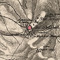 Historical map series for the area of Abu Shusha (1870s).jpg 739 × 742; 245 KB
-
 Tell Jezer from the 1871-77 Palestine Exploration Fund Survey of Palestine.jpg 2,752 × 2,053; 1.48 MB
-

-
 Historical map series for the area of Abu Shusha (1940s).jpg 739 × 742; 281 KB
-
 Kharruba 1942.jpg 438 × 335; 100 KB
-
 Salbit 1942.jpg 5,906 × 2,008; 3.31 MB
-
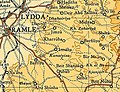
 Lydda and Ramla area - 9 July 1948.PNG 823 × 1,263; 92 KB
-
 Historical map series for the area of Abu Shusha (modern).jpg 739 × 742; 69 KB
.jpg)

.jpg)
.jpg)


.jpg)